


Transardennaise : Étape 2

Clem__lu
User

Length
26 km

Max alt
565 m

Uphill gradient
625 m
Km-Effort
34 km

Min alt
381 m

Downhill gradient
543 m
Boucle
No
Creation date :
2021-02-24 09:55:19.209
Updated on :
2021-02-24 15:49:44.496
5h35
Difficulty : Medium

FREE GPS app for hiking
 SityTrail
IGN / Geographical institutes
SityTrail Plus
The world is yours!
About
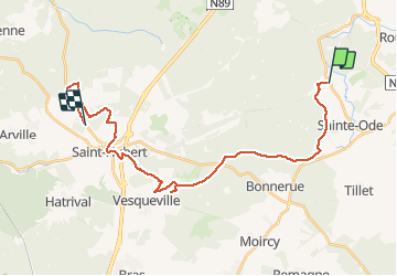
Trail Walking of 26 km to be discovered at Wallonia, Luxembourg, Sainte-Ode. This trail is proposed by Clem__lu.
Description
Lavacherie - Saint-Hubert (monument Roi Albert)
Positioning
Country:
Belgium
Region :
Wallonia
Department/Province :
Luxembourg
Municipality :
Sainte-Ode
Location:
Lavacherie
Start:(Dec)
Start:(UTM)
679770 ; 5547551 (31U) N.
Comments