


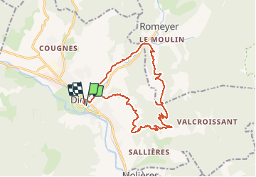
Die - Pas de Sagatte.

chamois07
User

Length
17.9 km

Max alt
991 m

Uphill gradient
759 m
Km-Effort
28 km

Min alt
406 m

Downhill gradient
757 m
Boucle
Yes
Creation date :
2021-02-25 07:42:56.0
Updated on :
2021-02-27 09:51:27.373
5h58
Difficulty : Medium

FREE GPS app for hiking
 SityTrail
IGN / Geographical institutes
SityTrail Plus
The world is yours!
About
Trail Walking of 17.9 km to be discovered at Auvergne-Rhône-Alpes, Drôme, Die. This trail is proposed by chamois07.
Description
Difficulté moyenne.
Belle vue sur le Glandasse- la dent de Die
Positioning
Country:
France
Region :
Auvergne-Rhône-Alpes
Department/Province :
Drôme
Municipality :
Die
Location:
Unknown
Start:(Dec)
Start:(UTM)
687845 ; 4958057 (31T) N.
Comments