


Le Pène Nère depuis la station de Peyragudes

yvesdelafforest
User
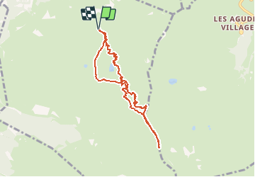

Length
8.2 km

Max alt
2263 m

Uphill gradient
603 m
Km-Effort
16.3 km

Min alt
1654 m

Downhill gradient
600 m
Boucle
Yes
Creation date :
2021-02-25 09:42:33.361
Updated on :
2021-02-28 17:24:22.842
4h00
Difficulty : Very easy

FREE GPS app for hiking
 SityTrail
IGN / Geographical institutes
SityTrail Plus
The world is yours!
About
Trail Touring skiing of 8.2 km to be discovered at Occitania, Hautespyrenees, Germ. This trail is proposed by yvesdelafforest.
Positioning
Country:
France
Region :
Occitania
Department/Province :
Hautespyrenees
Municipality :
Germ
Location:
Unknown
Start:(Dec)
Start:(UTM)
290921 ; 4740311 (31T) N.
Comments