


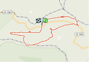
Hammelsberg

mrcat
User

Length
5.1 km

Max alt
397 m

Uphill gradient
129 m
Km-Effort
6.8 km

Min alt
284 m

Downhill gradient
128 m
Boucle
Yes
Creation date :
2021-02-26 08:24:57.214
Updated on :
2021-02-26 09:59:30.851
1h34
Difficulty : Easy

FREE GPS app for hiking
 SityTrail
IGN / Geographical institutes
SityTrail Plus
The world is yours!
About
Trail Walking of 5.1 km to be discovered at Grand Est, Bas-Rhin, Neuwiller-lès-Saverne. This trail is proposed by mrcat.
Positioning
Country:
France
Region :
Grand Est
Department/Province :
Bas-Rhin
Municipality :
Neuwiller-lès-Saverne
Location:
Unknown
Start:(Dec)
Start:(UTM)
380226 ; 5411804 (32U) N.
Comments
