


Mix moine rouge labyrinthe

starco
User
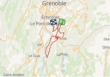

Length
56 km

Max alt
710 m

Uphill gradient
1841 m
Km-Effort
81 km

Min alt
263 m

Downhill gradient
1846 m
Boucle
Yes
Creation date :
2021-02-26 09:50:56.0
Updated on :
2021-02-26 15:28:10.383
5h36
Difficulty : Unknown

FREE GPS app for hiking
 SityTrail
IGN / Geographical institutes
SityTrail Plus
The world is yours!
About
Trail Mountain bike of 56 km to be discovered at Auvergne-Rhône-Alpes, Isère, Jarrie. This trail is proposed by starco.
Positioning
Country:
France
Region :
Auvergne-Rhône-Alpes
Department/Province :
Isère
Municipality :
Jarrie
Location:
Unknown
Start:(Dec)
Start:(UTM)
716594 ; 4998446 (31T) N.
Comments