


Theys

nathr
User
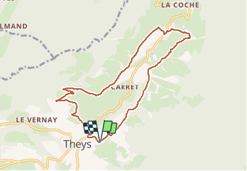

Length
9.1 km

Max alt
928 m

Uphill gradient
326 m
Km-Effort
13.4 km

Min alt
637 m

Downhill gradient
327 m
Boucle
Yes
Creation date :
2021-02-26 14:25:53.405
Updated on :
2021-02-26 20:47:24.369
1h56
Difficulty : Medium

FREE GPS app for hiking
 SityTrail
IGN / Geographical institutes
SityTrail Plus
The world is yours!
About
Trail Walking of 9.1 km to be discovered at Auvergne-Rhône-Alpes, Isère, Theys. This trail is proposed by nathr.
Description
Randonnée vers le Barrioz
Positioning
Country:
France
Region :
Auvergne-Rhône-Alpes
Department/Province :
Isère
Municipality :
Theys
Location:
Unknown
Start:(Dec)
Start:(UTM)
264926 ; 5020847 (32T) N.
Comments