


RS-Plan-Les étangs

raymondfn
User
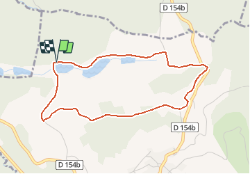

Length
4.3 km

Max alt
571 m

Uphill gradient
97 m
Km-Effort
5.6 km

Min alt
481 m

Downhill gradient
95 m
Boucle
Yes
Creation date :
2021-02-27 13:51:55.161
Updated on :
2021-02-27 13:54:31.006
1h16
Difficulty : Easy

FREE GPS app for hiking
 SityTrail
IGN / Geographical institutes
SityTrail Plus
The world is yours!
About
Trail Walking of 4.3 km to be discovered at Auvergne-Rhône-Alpes, Isère, Plan. This trail is proposed by raymondfn.
Description
Parcours à vérifier pente
Positioning
Country:
France
Region :
Auvergne-Rhône-Alpes
Department/Province :
Isère
Municipality :
Plan
Location:
Unknown
Start:(Dec)
Start:(UTM)
686552 ; 5021608 (31T) N.
Comments