


At léger

adamfv
User
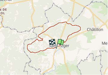

Length
12.8 km

Max alt
349 m

Uphill gradient
203 m
Km-Effort
15.5 km

Min alt
259 m

Downhill gradient
203 m
Boucle
Yes
Creation date :
2021-02-27 10:54:56.0
Updated on :
2021-02-27 14:16:20.586
3h21
Difficulty : Unknown

FREE GPS app for hiking
 SityTrail
IGN / Geographical institutes
SityTrail Plus
The world is yours!
About
Trail Walking of 12.8 km to be discovered at Wallonia, Luxembourg, Saint-Léger. This trail is proposed by adamfv.
Positioning
Country:
Belgium
Region :
Wallonia
Department/Province :
Luxembourg
Municipality :
Saint-Léger
Location:
Saint-Léger
Start:(Dec)
Start:(UTM)
691744 ; 5498764 (31U) N.
Comments