


Saint Génisse

Pascal Bernaud
User

Length
11.8 km

Max alt
309 m

Uphill gradient
181 m
Km-Effort
14.3 km

Min alt
222 m

Downhill gradient
179 m
Boucle
Yes
Creation date :
2021-02-27 13:13:36.0
Updated on :
2021-02-27 16:04:17.491
2h50
Difficulty : Unknown

FREE GPS app for hiking
 SityTrail
IGN / Geographical institutes
SityTrail Plus
The world is yours!
About
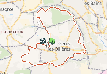
Trail Walking of 11.8 km to be discovered at Auvergne-Rhône-Alpes, Métropole de Lyon, Saint-Genis-les-Ollières. This trail is proposed by Pascal Bernaud.
Positioning
Country:
France
Region :
Auvergne-Rhône-Alpes
Department/Province :
Métropole de Lyon
Municipality :
Saint-Genis-les-Ollières
Location:
Unknown
Start:(Dec)
Start:(UTM)
633772 ; 5068771 (31T) N.
Comments