


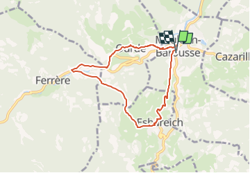
Mauleon Barousse-Esbareich-Ourde

mitch1952
User

Length
7.2 km

Max alt
784 m

Uphill gradient
308 m
Km-Effort
11.3 km

Min alt
574 m

Downhill gradient
308 m
Boucle
Yes
Creation date :
2021-02-27 17:07:20.989
Updated on :
2022-06-08 11:01:50.453
3h00
Difficulty : Very easy

FREE GPS app for hiking
 SityTrail
IGN / Geographical institutes
SityTrail Plus
The world is yours!
About
Trail On foot of 7.2 km to be discovered at Occitania, Hautespyrenees, Mauléon-Barousse. This trail is proposed by mitch1952.
Positioning
Country:
France
Region :
Occitania
Department/Province :
Hautespyrenees
Municipality :
Mauléon-Barousse
Location:
Unknown
Start:(Dec)
Start:(UTM)
301561 ; 4759037 (31T) N.
Comments