


nanton 28 02 2021 14km

desbois
User
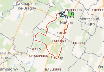

Length
14 km

Max alt
273 m

Uphill gradient
147 m
Km-Effort
15.9 km

Min alt
184 m

Downhill gradient
149 m
Boucle
Yes
Creation date :
2021-02-28 08:45:20.065
Updated on :
2021-02-28 13:16:28.665
3h44
Difficulty : Very easy

FREE GPS app for hiking
 SityTrail
IGN / Geographical institutes
SityTrail Plus
The world is yours!
About
Trail Walking of 14 km to be discovered at Bourgogne-Franche-Comté, Saône-et-Loire, Nanton. This trail is proposed by desbois.
Description
170m de Dénivelé
Positioning
Country:
France
Region :
Bourgogne-Franche-Comté
Department/Province :
Saône-et-Loire
Municipality :
Nanton
Location:
Unknown
Start:(Dec)
Start:(UTM)
639019 ; 5164659 (31T) N.
Comments