


GR34-EtapeIII-J05

JMCMoreau
User
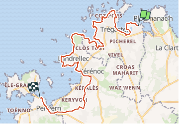

Length
19.2 km

Max alt
45 m

Uphill gradient
158 m
Km-Effort
21 km

Min alt
0 m

Downhill gradient
155 m
Boucle
No
Creation date :
2021-02-28 16:24:48.234
Updated on :
2023-01-21 17:35:24.348
6h30
Difficulty : Easy

FREE GPS app for hiking
 SityTrail
IGN / Geographical institutes
SityTrail Plus
The world is yours!
About
Trail Walking of 19.2 km to be discovered at Brittany, Côtes-d'Armor, Trégastel. This trail is proposed by JMCMoreau.
Description
Depuis la plage de Tourony (Ploumanac'h) jusqu'à l'entrée de l'Île Grande Parking de la Plage du Mouton. Prévoir 6h30 avec les pauses
Positioning
Country:
France
Region :
Brittany
Department/Province :
Côtes-d'Armor
Municipality :
Trégastel
Location:
Unknown
Start:(Dec)
Start:(UTM)
463701 ; 5408479 (30U) N.
Comments
Tout va bien