


mont avril

XavierFaidix
User
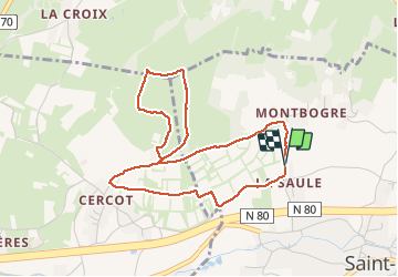

Length
4.3 km

Max alt
414 m

Uphill gradient
155 m
Km-Effort
6.4 km

Min alt
250 m

Downhill gradient
160 m
Boucle
Yes
Creation date :
2021-02-28 13:57:58.316
Updated on :
2021-02-28 16:48:42.715
1h07
Difficulty : Medium

FREE GPS app for hiking
 SityTrail
IGN / Geographical institutes
SityTrail Plus
The world is yours!
About
Trail Walking of 4.3 km to be discovered at Bourgogne-Franche-Comté, Saône-et-Loire, Saint-Désert. This trail is proposed by XavierFaidix.
Positioning
Country:
France
Region :
Bourgogne-Franche-Comté
Department/Province :
Saône-et-Loire
Municipality :
Saint-Désert
Location:
Unknown
Start:(Dec)
Start:(UTM)
629979 ; 5179819 (31T) N.
Comments