


Termes Nitable Roc

Ada11
User GUIDE
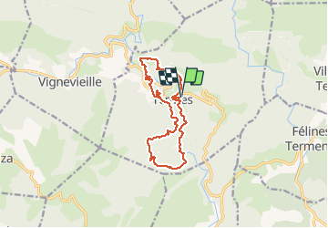

Length
14.7 km

Max alt
589 m

Uphill gradient
603 m
Km-Effort
23 km

Min alt
246 m

Downhill gradient
604 m
Boucle
Yes
Creation date :
2021-02-28 08:40:01.712
Updated on :
2021-02-28 17:24:18.263
4h03
Difficulty : Medium

FREE GPS app for hiking
 SityTrail
IGN / Geographical institutes
SityTrail Plus
The world is yours!
About
Trail Walking of 14.7 km to be discovered at Occitania, Aude, Termes. This trail is proposed by Ada11.
Description
Très belle rando. Nous avons raté le chemin facile pour descendre à la cascade, au niveau de la route, du coup on a pris un sentier difficile mais rigolo, avant de retrouver le bon plus bas.
Photos


Positioning
Country:
France
Region :
Occitania
Department/Province :
Aude
Municipality :
Termes
Location:
Unknown
Start:(Dec)
Start:(UTM)
464585 ; 4761010 (31T) N.
Comments