


estoublon

Clo0413
User
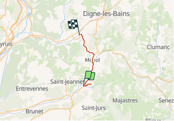

Length
21 km

Max alt
812 m

Uphill gradient
493 m
Km-Effort
27 km

Min alt
509 m

Downhill gradient
484 m
Boucle
No
Creation date :
2021-02-28 10:02:35.02
Updated on :
2021-02-28 19:08:30.991
2h13
Difficulty : Very easy

FREE GPS app for hiking
 SityTrail
IGN / Geographical institutes
SityTrail Plus
The world is yours!
About
Trail Walking of 21 km to be discovered at Provence-Alpes-Côte d'Azur, Alpes-de-Haute-Provence, Estoublon. This trail is proposed by Clo0413.
Positioning
Country:
France
Region :
Provence-Alpes-Côte d'Azur
Department/Province :
Alpes-de-Haute-Provence
Municipality :
Estoublon
Location:
Unknown
Start:(Dec)
Start:(UTM)
272876 ; 4869374 (32T) N.
Comments