Trail Walking Capdenac-Gare - 2014-04-21 15h51m35 - Photo

2014-04-21 15h51m35

 xamax12
xamax12

User

© OpenStreetMap contributors
Length
Length
8.9 km
Max alt
Max alt
276 m
Uphill gradient
Uphill gradient
176 m
Km-Effort
Km-Effort  
11.2 km
Min alt
Min alt
162 m
Downhill gradient
Downhill gradient
177 m
Boucle
Boucle
Yes
Creation date :
2014-12-10 00:00:00.0
Updated on :
2014-12-10 00:00:00.0

(1 Reviews)

Walking
Walking
2h00
Difficulty : Easy

Scan this QR Code to open this trail in the SityTrail application

FREE GPS app for hiking

Logo SityTrail SityTrail

IGN / Geographical institutes

Download SityTrail from the App Store Download SityTrail from Google Play

Logo SityTrail SityTrail Plus

The world is yours!

Download SityTrail from the App Store Download SityTrail from Google Play Download SityTrail on Huawei AppGallery

About

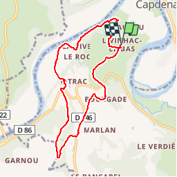
Trail Walking of 8.9 km to be discovered at Occitania, Aveyron, Capdenac-Gare. This trail is proposed by xamax12.

Description

Suivre le balisage jaune sauf au début sur 1km  pour rejoindre Sarrou et à la fin environ 1km aussi pour rejoindre Livinhac le bas (D'autre chemins sont possible pour le retour)! Sinon c'est une belle promenade avec 2 moulin et pas mal de bois!

Elevation profile

Positioning

Country:
France
Region :
Occitania
Department/Province :
Aveyron
Municipality :
Capdenac-Gare
Location:
Unknown
Start:(UTM)
425001 ; 4936014 (31T) N.

Comments

Please log in to post a review or rate the element


Close
My subscriptions