


2021-03-01_12h48m04_SityTrail - 2682238 - les-granges-de-pan-cauterets

mitch1952
User
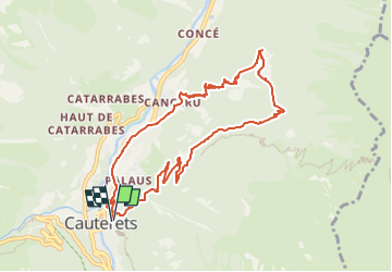

Length
10.6 km

Max alt
1392 m

Uphill gradient
579 m
Km-Effort
18.3 km

Min alt
869 m

Downhill gradient
579 m
Boucle
Yes
Creation date :
2021-03-01 11:48:04.166
Updated on :
2022-06-08 11:01:02.137
4h09
Difficulty : Difficult

FREE GPS app for hiking
 SityTrail
IGN / Geographical institutes
SityTrail Plus
The world is yours!
About
Trail Walking of 10.6 km to be discovered at Occitania, Hautespyrenees, Cauterets. This trail is proposed by mitch1952.
Positioning
Country:
France
Region :
Occitania
Department/Province :
Hautespyrenees
Municipality :
Cauterets
Location:
Unknown
Start:(Dec)
Start:(UTM)
735783 ; 4752603 (30T) N.
Comments