


Ent20210301

Valery01
User

Length
11.4 km

Max alt
303 m

Uphill gradient
300 m
Km-Effort
15.4 km

Min alt
178 m

Downhill gradient
300 m
Boucle
Yes
Creation date :
2021-03-01 10:52:48.0
Updated on :
2021-03-01 12:30:32.066
1h36
Difficulty : Unknown

FREE GPS app for hiking
 SityTrail
IGN / Geographical institutes
SityTrail Plus
The world is yours!
About
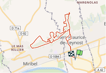
Trail Trail of 11.4 km to be discovered at Auvergne-Rhône-Alpes, Ain, Saint-Maurice-de-Beynost. This trail is proposed by Valery01.
Positioning
Country:
France
Region :
Auvergne-Rhône-Alpes
Department/Province :
Ain
Municipality :
Saint-Maurice-de-Beynost
Location:
Unknown
Start:(Dec)
Start:(UTM)
653737 ; 5076561 (31T) N.
Comments