


Coteaux crolles Fabio

starco
User
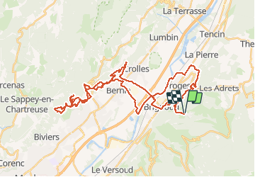

Length
51 km

Max alt
722 m

Uphill gradient
1976 m
Km-Effort
77 km

Min alt
223 m

Downhill gradient
1972 m
Boucle
Yes
Creation date :
2021-03-01 12:43:44.0
Updated on :
2021-03-01 16:47:58.113
4h03
Difficulty : Difficult

FREE GPS app for hiking
 SityTrail
IGN / Geographical institutes
SityTrail Plus
The world is yours!
About
Trail Mountain bike of 51 km to be discovered at Auvergne-Rhône-Alpes, Isère, Laval-en-Belledonne. This trail is proposed by starco.
Positioning
Country:
France
Region :
Auvergne-Rhône-Alpes
Department/Province :
Isère
Municipality :
Laval-en-Belledonne
Location:
Unknown
Start:(Dec)
Start:(UTM)
729965 ; 5015375 (31T) N.
Comments