


Alan

pidjam
User

Length
10.8 km

Max alt
396 m

Uphill gradient
304 m
Km-Effort
14.9 km

Min alt
275 m

Downhill gradient
301 m
Boucle
Yes
Creation date :
2021-03-02 13:47:58.205
Updated on :
2021-03-02 13:48:52.946
3h22
Difficulty : Difficult

FREE GPS app for hiking
 SityTrail
IGN / Geographical institutes
SityTrail Plus
The world is yours!
About
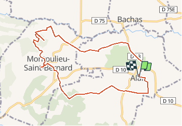
Trail Walking of 10.8 km to be discovered at Occitania, Haute-Garonne, Alan. This trail is proposed by pidjam.
Description
Alan, fontaine de Montoulieu St Bernard et vestiges gallo romains
Positioning
Country:
France
Region :
Occitania
Department/Province :
Haute-Garonne
Municipality :
Alan
Location:
Unknown
Start:(Dec)
Start:(UTM)
332757 ; 4788368 (31T) N.
Comments