


Queyrieres Suc Montchanis suc Montrouge

psesjs
User
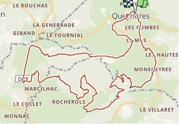

Length
18 km

Max alt
1200 m

Uphill gradient
778 m
Km-Effort
28 km

Min alt
901 m

Downhill gradient
780 m
Boucle
Yes
Creation date :
2021-03-03 08:32:20.525
Updated on :
2021-03-03 15:12:06.296
4h41
Difficulty : Very easy

FREE GPS app for hiking
 SityTrail
IGN / Geographical institutes
SityTrail Plus
The world is yours!
About
Trail Walking of 18 km to be discovered at Auvergne-Rhône-Alpes, Haute-Loire, Queyrières. This trail is proposed by psesjs.
Positioning
Country:
France
Region :
Auvergne-Rhône-Alpes
Department/Province :
Haute-Loire
Municipality :
Queyrières
Location:
Unknown
Start:(Dec)
Start:(UTM)
586601 ; 4991664 (31T) N.
Comments