


Transardennaise : étape 6

Clem__lu
User

Length
27 km

Max alt
462 m

Uphill gradient
531 m
Km-Effort
34 km

Min alt
215 m

Downhill gradient
691 m
Boucle
No
Creation date :
2021-03-03 09:48:28.887
Updated on :
2021-03-03 15:51:13.959
5h47
Difficulty : Easy

FREE GPS app for hiking
 SityTrail
IGN / Geographical institutes
SityTrail Plus
The world is yours!
About
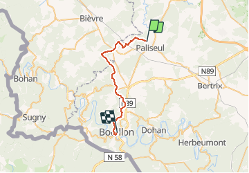
Trail Walking of 27 km to be discovered at Wallonia, Luxembourg, Paliseul. This trail is proposed by Clem__lu.
Description
Paliseul - Bouillon
Positioning
Country:
Belgium
Region :
Wallonia
Department/Province :
Luxembourg
Municipality :
Paliseul
Location:
Paliseul
Start:(Dec)
Start:(UTM)
652804 ; 5530854 (31U) N.
Comments