


Amby

bellou17
User
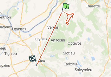

Length
19.1 km

Max alt
424 m

Uphill gradient
605 m
Km-Effort
27 km

Min alt
212 m

Downhill gradient
603 m
Boucle
No
Creation date :
2021-03-04 08:38:24.0
Updated on :
2021-03-04 10:42:34.842
1h13
Difficulty : Unknown

FREE GPS app for hiking
 SityTrail
IGN / Geographical institutes
SityTrail Plus
The world is yours!
About
Trail Running of 19.1 km to be discovered at Auvergne-Rhône-Alpes, Isère, Hières-sur-Amby. This trail is proposed by bellou17.
Positioning
Country:
France
Region :
Auvergne-Rhône-Alpes
Department/Province :
Isère
Municipality :
Hières-sur-Amby
Location:
Unknown
Start:(Dec)
Start:(UTM)
678805 ; 5074276 (31T) N.
Comments