


Chemin de St-Guilhem - étape 08 : Meyrueis - L'Espérou

cathel11
User
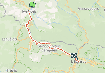

Length
21 km

Max alt
1334 m

Uphill gradient
885 m
Km-Effort
31 km

Min alt
704 m

Downhill gradient
368 m
Boucle
No
Creation date :
2021-03-04 11:50:38.9
Updated on :
2022-01-16 19:33:43.29
7h08
Difficulty : Very difficult

FREE GPS app for hiking
 SityTrail
IGN / Geographical institutes
SityTrail Plus
The world is yours!
About
Trail Walking of 21 km to be discovered at Occitania, Lozère, Meyrueis. This trail is proposed by cathel11.
Positioning
Country:
France
Region :
Occitania
Department/Province :
Lozère
Municipality :
Meyrueis
Location:
Unknown
Start:(Dec)
Start:(UTM)
534239 ; 4891690 (31T) N.
Comments