


vernon cascade beaumicou les tetines

Dan30
User
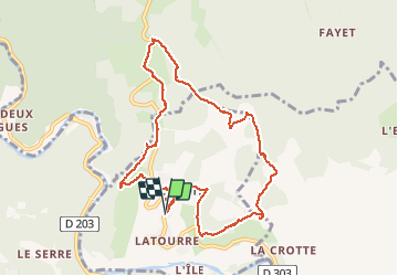

Length
11.2 km

Max alt
503 m

Uphill gradient
378 m
Km-Effort
16.2 km

Min alt
232 m

Downhill gradient
378 m
Boucle
Yes
Creation date :
2021-03-04 08:57:59.617
Updated on :
2021-03-04 14:07:43.507
5h08
Difficulty : Easy

FREE GPS app for hiking
 SityTrail
IGN / Geographical institutes
SityTrail Plus
The world is yours!
About
Trail Walking of 11.2 km to be discovered at Auvergne-Rhône-Alpes, Ardèche, Vernon. This trail is proposed by Dan30.
Positioning
Country:
France
Region :
Auvergne-Rhône-Alpes
Department/Province :
Ardèche
Municipality :
Vernon
Location:
Unknown
Start:(Dec)
Start:(UTM)
597239 ; 4928675 (31T) N.
Comments