
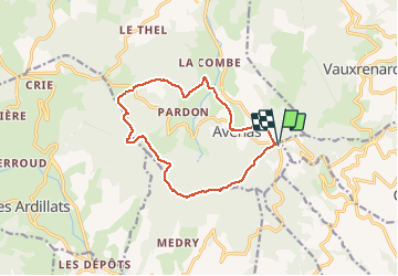
Fût d’Avenas (13 km - D. 455 m)

Thomasdanielle
User

Length
13 km

Max alt
891 m

Uphill gradient
455 m
Km-Effort
19.1 km

Min alt
537 m

Downhill gradient
456 m
Boucle
Yes
Creation date :
2021-03-04 09:14:40.0
Updated on :
2021-03-05 11:00:41.761
4h21
Difficulty : Medium

FREE GPS app for hiking
 SityTrail
IGN / Geographical institutes
SityTrail Plus
The world is yours!
About
Trail Walking of 13 km to be discovered at Auvergne-Rhône-Alpes, Rhône, Chiroubles. This trail is proposed by Thomasdanielle.
Description
D/A : Se garer au parking du Col du Fût d'Avenas.
Photos
 - Photo 1")
 - Photo 2")
 - Photo 3")
Positioning
Country:
France
Region :
Auvergne-Rhône-Alpes
Department/Province :
Rhône
Municipality :
Chiroubles
Location:
Unknown
Start:(Dec)
Start:(UTM)
624905 ; 5116649 (31T) N.
Comments