


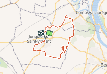
JONQUIERES ST VINCENT Source de Tavie

Manoune
User


--
Difficulty : Easy

FREE GPS app for hiking
 SityTrail
IGN / Geographical institutes
SityTrail Plus
The world is yours!
About
Trail On foot of 15.7 km to be discovered at Occitania, Gard, Jonquières-Saint-Vincent. This trail is proposed by Manoune.
Description
Départ parking du marché - Pieu Redon , Via Domitia, La Tombe, le Cros de l'Argent, Mourre Goyen, la Roustine, Mas Sicard , Bos de Soulon, Mas du Maire,il est possible de se rendre à la voie verte et l'aire de pique-nique et revenir sur ses pas ensuite, Source de Tavie, les Sayardes, Font Couverte, parking.
Positioning
Comments