


conqudyrac

Bwattier
User
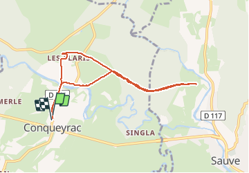

Length
8.1 km

Max alt
150 m

Uphill gradient
106 m
Km-Effort
9.5 km

Min alt
114 m

Downhill gradient
105 m
Boucle
Yes
Creation date :
2021-03-04 13:52:50.804
Updated on :
2021-03-04 15:39:19.559
1h46
Difficulty : Very easy

FREE GPS app for hiking
 SityTrail
IGN / Geographical institutes
SityTrail Plus
The world is yours!
About
Trail Walking of 8.1 km to be discovered at Occitania, Gard, Conqueyrac. This trail is proposed by Bwattier.
Positioning
Country:
France
Region :
Occitania
Department/Province :
Gard
Municipality :
Conqueyrac
Location:
Unknown
Start:(Dec)
Start:(UTM)
572895 ; 4866602 (31T) N.
Comments