


rando du 19 février 2021

gillou1947
User
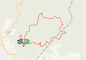

Length
10.5 km

Max alt
251 m

Uphill gradient
292 m
Km-Effort
14.3 km

Min alt
71 m

Downhill gradient
292 m
Boucle
Yes
Creation date :
2021-02-19 07:46:23.885
Updated on :
2021-03-05 07:58:36.247
2h45
Difficulty : Very easy

FREE GPS app for hiking
 SityTrail
IGN / Geographical institutes
SityTrail Plus
The world is yours!
About
Trail Walking of 10.5 km to be discovered at Provence-Alpes-Côte d'Azur, Var, Fréjus. This trail is proposed by gillou1947.
Photos

Positioning
Country:
France
Region :
Provence-Alpes-Côte d'Azur
Department/Province :
Var
Municipality :
Fréjus
Location:
Unknown
Start:(Dec)
Start:(UTM)
320500 ; 4814937 (32T) N.
Comments