


Liaucous_Troglodytes

jagarnier
User GUIDE
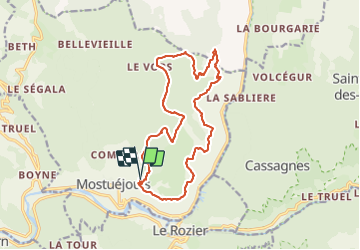

Length
16.5 km

Max alt
948 m

Uphill gradient
648 m
Km-Effort
25 km

Min alt
471 m

Downhill gradient
648 m
Boucle
Yes
Creation date :
2021-03-05 10:31:36.609
Updated on :
2021-08-24 04:50:38.314
6h00
Difficulty : Difficult

FREE GPS app for hiking
 SityTrail
IGN / Geographical institutes
SityTrail Plus
The world is yours!
About
Trail Walking of 16.5 km to be discovered at Occitania, Aveyron, Mostuéjouls. This trail is proposed by jagarnier.
Positioning
Country:
France
Region :
Occitania
Department/Province :
Aveyron
Municipality :
Mostuéjouls
Location:
Unknown
Start:(Dec)
Start:(UTM)
515537 ; 4894508 (31T) N.
Comments