


Bous hernri par derrière

patsab78
User
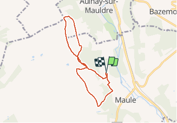

Length
6.6 km

Max alt
125 m

Uphill gradient
117 m
Km-Effort
8.2 km

Min alt
45 m

Downhill gradient
115 m
Boucle
Yes
Creation date :
2021-03-05 14:04:48.0
Updated on :
2021-03-05 15:31:11.188
1h25
Difficulty : Unknown

FREE GPS app for hiking
 SityTrail
IGN / Geographical institutes
SityTrail Plus
The world is yours!
About
Trail Walking of 6.6 km to be discovered at Ile-de-France, Yvelines, Maule. This trail is proposed by patsab78.
Description
Plateau derrière bous henri
Retour charcot
Positioning
Country:
France
Region :
Ile-de-France
Department/Province :
Yvelines
Municipality :
Maule
Location:
Unknown
Start:(Dec)
Start:(UTM)
415285 ; 5418560 (31U) N.
Comments