


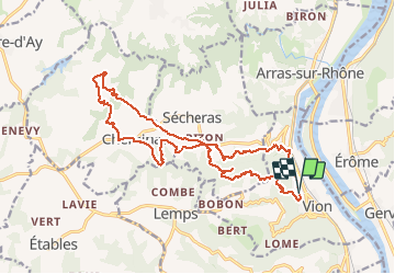
Vion - Cheminas - chateau ruiné d'iserand

Danielle07
User

Length
16.6 km

Max alt
468 m

Uphill gradient
543 m
Km-Effort
24 km

Min alt
126 m

Downhill gradient
544 m
Boucle
Yes
Creation date :
2021-03-06 10:12:44.404
Updated on :
2024-12-17 15:06:45.488
5h25
Difficulty : Medium

FREE GPS app for hiking
 SityTrail
IGN / Geographical institutes
SityTrail Plus
The world is yours!
About
Trail On foot of 16.6 km to be discovered at Auvergne-Rhône-Alpes, Ardèche, Vion. This trail is proposed by Danielle07.
Description
possibilités de réduire les km à plusieurs endroits
Positioning
Country:
France
Region :
Auvergne-Rhône-Alpes
Department/Province :
Ardèche
Municipality :
Vion
Location:
Unknown
Start:(Dec)
Start:(UTM)
641856 ; 4997045 (31T) N.
Comments