


Montfaucon

i20
User
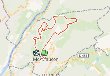

Length
8.9 km

Max alt
606 m

Uphill gradient
267 m
Km-Effort
12.5 km

Min alt
397 m

Downhill gradient
266 m
Boucle
Yes
Creation date :
2021-03-06 13:18:23.323
Updated on :
2021-03-06 16:05:09.958
2h46
Difficulty : Very easy

FREE GPS app for hiking
 SityTrail
IGN / Geographical institutes
SityTrail Plus
The world is yours!
About
Trail Walking of 8.9 km to be discovered at Bourgogne-Franche-Comté, Doubs, Montfaucon. This trail is proposed by i20.
Positioning
Country:
France
Region :
Bourgogne-Franche-Comté
Department/Province :
Doubs
Municipality :
Montfaucon
Location:
Unknown
Start:(Dec)
Start:(UTM)
278807 ; 5235411 (32T) N.
Comments