


Saint Côme Roquelaure

limo12
User
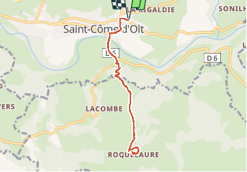

Length
8.4 km

Max alt
708 m

Uphill gradient
392 m
Km-Effort
13.6 km

Min alt
348 m

Downhill gradient
391 m
Boucle
Yes
Creation date :
2021-03-06 13:35:30.402
Updated on :
2021-03-06 16:37:20.921
2h26
Difficulty : Medium

FREE GPS app for hiking
 SityTrail
IGN / Geographical institutes
SityTrail Plus
The world is yours!
About
Trail Walking of 8.4 km to be discovered at Occitania, Aveyron, Saint-Côme-d'Olt. This trail is proposed by limo12.
Description
Montée de Saint Côme vers Roqulaure par GR620
Positioning
Country:
France
Region :
Occitania
Department/Province :
Aveyron
Municipality :
Saint-Côme-d'Olt
Location:
Unknown
Start:(Dec)
Start:(UTM)
485810 ; 4929287 (31T) N.
Comments