


la bastide en val

elexine23
User
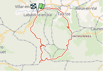

Length
19.7 km

Max alt
745 m

Uphill gradient
598 m
Km-Effort
28 km

Min alt
224 m

Downhill gradient
597 m
Boucle
Yes
Creation date :
2021-03-07 07:57:27.211
Updated on :
2021-03-07 14:42:46.435
6h01
Difficulty : Easy

FREE GPS app for hiking
 SityTrail
IGN / Geographical institutes
SityTrail Plus
The world is yours!
About
Trail Walking of 19.7 km to be discovered at Occitania, Aude, Labastide-en-Val. This trail is proposed by elexine23.
Positioning
Country:
France
Region :
Occitania
Department/Province :
Aude
Municipality :
Labastide-en-Val
Location:
Unknown
Start:(Dec)
Start:(UTM)
457116 ; 4769592 (31T) N.
Comments