


Collobrières Les Mayons ,plaine des Maures col de taillelude

lauvernet
User
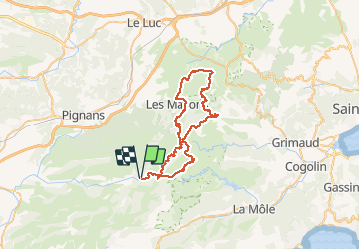

Length
55 km

Max alt
657 m

Uphill gradient
1259 m
Km-Effort
72 km

Min alt
84 m

Downhill gradient
1259 m
Boucle
Yes
Creation date :
2021-03-07 17:48:01.78
Updated on :
2021-03-07 17:50:04.79
5h00
Difficulty : Very difficult

FREE GPS app for hiking
 SityTrail
IGN / Geographical institutes
SityTrail Plus
The world is yours!
About
Trail Mountain bike of 55 km to be discovered at Provence-Alpes-Côte d'Azur, Var, Collobrières. This trail is proposed by lauvernet.
Positioning
Country:
France
Region :
Provence-Alpes-Côte d'Azur
Department/Province :
Var
Municipality :
Collobrières
Location:
Unknown
Start:(Dec)
Start:(UTM)
281644 ; 4790807 (32T) N.
Comments