


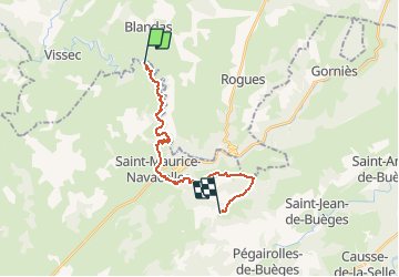
Chemin de St-Guilhem - étape 11 : Navacelles - Natges

cathel11
User

Length
18.7 km

Max alt
626 m

Uphill gradient
628 m
Km-Effort
27 km

Min alt
264 m

Downhill gradient
481 m
Boucle
No
Creation date :
2021-03-07 17:52:07.496
Updated on :
2021-03-07 17:52:51.09
6h02
Difficulty : Very difficult

FREE GPS app for hiking
 SityTrail
IGN / Geographical institutes
SityTrail Plus
The world is yours!
About
Trail Walking of 18.7 km to be discovered at Occitania, Hérault, Saint-Maurice-Navacelles. This trail is proposed by cathel11.
Positioning
Country:
France
Region :
Occitania
Department/Province :
Hérault
Municipality :
Saint-Maurice-Navacelles
Location:
Unknown
Start:(Dec)
Start:(UTM)
541022 ; 4860299 (31T) N.
Comments