


Nohan sur Semoy - Hautes Rivières - La Croix de l'Enfer - Les Crètes

Superpape
User
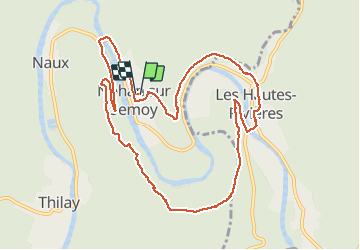

Length
10.4 km

Max alt
344 m

Uphill gradient
292 m
Km-Effort
14.2 km

Min alt
155 m

Downhill gradient
292 m
Boucle
Yes
Creation date :
2021-03-08 13:27:23.396
Updated on :
2021-03-29 09:01:46.947
2h21
Difficulty : Very easy

FREE GPS app for hiking
 SityTrail
IGN / Geographical institutes
SityTrail Plus
The world is yours!
About
Trail Walking of 10.4 km to be discovered at Grand Est, Ardennes, Thilay. This trail is proposed by Superpape.
Positioning
Country:
France
Region :
Grand Est
Department/Province :
Ardennes
Municipality :
Thilay
Location:
Unknown
Start:(Dec)
Start:(UTM)
630887 ; 5527497 (31U) N.
Comments