Trail Nordic walking Roquebrune-sur-Argens - Palayson - Photo
© OpenStreetMap contributors
Length
Length
19.1 km
Max alt
Max alt
91 m
Uphill gradient
Uphill gradient
199 m
Km-Effort
Km-Effort  
22 km
Min alt
Min alt
1 m
Downhill gradient
Downhill gradient
267 m
Boucle
Boucle
No
Creation date :
2021-03-08 10:08:26.786
Updated on :
2021-03-08 20:07:58.089

(0 Reviews)

Nordic walking
Nordic walking
1h21
Difficulty : Medium

Scan this QR Code to open this trail in the SityTrail application

FREE GPS app for hiking

Logo SityTrail SityTrail

IGN / Geographical institutes

Download SityTrail from the App Store Download SityTrail from Google Play

Logo SityTrail SityTrail World

The world is yours!

Download SityTrail from the App Store Download SityTrail from Google Play Download SityTrail on Huawei AppGallery

About

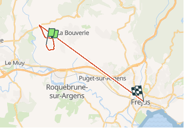
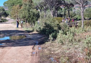
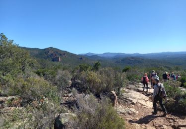
Trail Nordic walking of 19.1 km to be discovered at Provence-Alpes-Côte d'Azur, Var, Roquebrune-sur-Argens. This trail is proposed by Mary.chicanne@gmail.com .

Elevation profile

Positioning

Country:
France
Region :
Provence-Alpes-Côte d'Azur
Department/Province :
Var
Municipality :
Roquebrune-sur-Argens
Location:
Unknown
Start:(UTM)
306671 ; 4817865 (32T) N.

Trails nearby

Trail Walking Le Muy - les grottes Baume Renaude - Photo
Walking
boulinevelyne

Walking

Difficult
(1)
Le Muy, Provence-Alpes-Côte d'Azur, Var, France
13.3 km | 18.3 km-effort
5h 13min
No
Trail Walking Bagnols-en-Forêt - La Colle du Rouet par le Castel Diaou - Le Muy - Photo
Walking
tracegps

Walking

Difficult
(2)
Bagnols-en-Forêt, Provence-Alpes-Côte d'Azur, Var, France
18.2 km | 27 km-effort
6h 0min
Yes
Trail Walking Roquebrune-sur-Argens - Rocher de Roquebrune, les Trois Croix - Photo
Walking
tracegps

Walking

Difficult
(4)
Roquebrune-sur-Argens, Provence-Alpes-Côte d'Azur, Var, France
7 km | 11.4 km-effort
4h 15min
Yes
Trail Walking Bagnols-en-Forêt - Gorges du Blavet au col de la pierre du coucou - Photo
Walking
GUIDE
nadinebondoux

Walking

Difficult
Bagnols-en-Forêt, Provence-Alpes-Côte d'Azur, Var, France
15.8 km | 22 km-effort
4h 44min
Yes
Trail Walking Le Muy - 2024-04-17_09h53m25_visorando-2024-04-19-les-roches-de-la-fille-isnard-gilles - Photo
Walking
GrouGary

Walking

Medium
Le Muy, Provence-Alpes-Côte d'Azur, Var, France
16.6 km | 23 km-effort
5h 16min
Yes
Trail On foot Roquebrune-sur-Argens - 2024-03-12_16h48m05_Randonn_e-44 - Photo
On foot
marsouin 83

On foot

Easy
(1)
Roquebrune-sur-Argens, Provence-Alpes-Côte d'Azur, Var, France
11.6 km | 16.2 km-effort
3h 41min
Yes
Trail Walking Le Muy - z le trou de la Jarre 12-03-24 - Photo
Walking
cb8310

Walking

Easy
Le Muy, Provence-Alpes-Côte d'Azur, Var, France
7.3 km | 8.3 km-effort
2h 32min
Yes
Trail Walking Roquebrune-sur-Argens - LA BOUVERIE / grottes /malvoisin/église des paiens/muerons - Photo
Walking
Michel DUBOIS

Walking

Medium
Roquebrune-sur-Argens, Provence-Alpes-Côte d'Azur, Var, France
12.2 km | 17.5 km-effort
3h 59min
Yes
Trail Walking Roquebrune-sur-Argens - Grottes de La Bouverie  - Photo
Walking
Pascal-83

Walking

Difficult
Roquebrune-sur-Argens, Provence-Alpes-Côte d'Azur, Var, France
10.1 km | 14.1 km-effort
3h 12min
Yes


Close
My subscriptions