


2021-03-09 Étangs de Commelles

Bernardb44
User
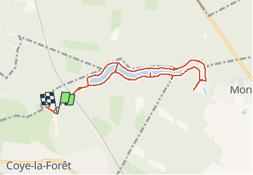

Length
9.1 km

Max alt
64 m

Uphill gradient
100 m
Km-Effort
10.4 km

Min alt
38 m

Downhill gradient
101 m
Boucle
Yes
Creation date :
2021-03-09 10:24:41.424
Updated on :
2021-03-09 14:59:12.69
3h34
Difficulty : Easy

FREE GPS app for hiking
 SityTrail
IGN / Geographical institutes
SityTrail Plus
The world is yours!
About
Trail Walking of 9.1 km to be discovered at Hauts-de-France, Oise, Coye-la-Forêt. This trail is proposed by Bernardb44.
Positioning
Country:
France
Region :
Hauts-de-France
Department/Province :
Oise
Municipality :
Coye-la-Forêt
Location:
Unknown
Start:(Dec)
Start:(UTM)
461500 ; 5444345 (31U) N.
Comments