


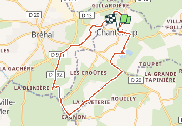
Chanteloup

FrancoiseVillalonga
User

Length
8.3 km

Max alt
72 m

Uphill gradient
77 m
Km-Effort
9.4 km

Min alt
28 m

Downhill gradient
79 m
Boucle
Yes
Creation date :
2021-03-09 13:32:48.0
Updated on :
2021-03-09 15:58:31.88
2h26
Difficulty : Unknown

FREE GPS app for hiking
 SityTrail
IGN / Geographical institutes
SityTrail Plus
The world is yours!
About
Trail Walking of 8.3 km to be discovered at Normandy, Manche, Chanteloup. This trail is proposed by FrancoiseVillalonga.
Positioning
Country:
France
Region :
Normandy
Department/Province :
Manche
Municipality :
Chanteloup
Location:
Unknown
Start:(Dec)
Start:(UTM)
610952 ; 5417330 (30U) N.
Comments