


ST GENIS LES OLIERES

erlch
User
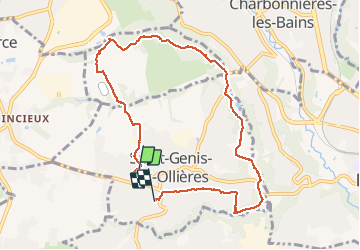

Length
8.5 km

Max alt
303 m

Uphill gradient
137 m
Km-Effort
10.3 km

Min alt
222 m

Downhill gradient
136 m
Boucle
No
Creation date :
2021-03-09 14:13:20.0
Updated on :
2021-03-09 16:27:39.697
2h12
Difficulty : Unknown

FREE GPS app for hiking
 SityTrail
IGN / Geographical institutes
SityTrail Plus
The world is yours!
About
Trail Walking of 8.5 km to be discovered at Auvergne-Rhône-Alpes, Métropole de Lyon, Saint-Genis-les-Ollières. This trail is proposed by erlch.
Positioning
Country:
France
Region :
Auvergne-Rhône-Alpes
Department/Province :
Métropole de Lyon
Municipality :
Saint-Genis-les-Ollières
Location:
Unknown
Start:(Dec)
Start:(UTM)
633830 ; 5068691 (31T) N.
Comments