


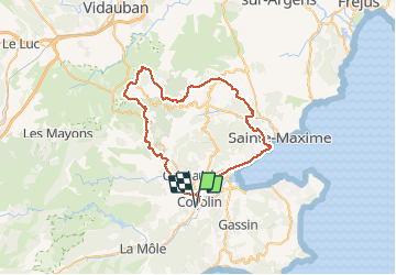
Cogolin La Garde Freinet ST Maxime

lauvernet
User

Length
62 km

Max alt
474 m

Uphill gradient
1242 m
Km-Effort
78 km

Min alt
0 m

Downhill gradient
1242 m
Boucle
Yes
Creation date :
2021-03-09 20:46:12.721
Updated on :
2021-03-09 20:48:34.192
5h25
Difficulty : Very difficult
--
Difficulty : Difficult

FREE GPS app for hiking
 SityTrail
IGN / Geographical institutes
SityTrail Plus
The world is yours!
About
Trail Mountain bike of 62 km to be discovered at Provence-Alpes-Côte d'Azur, Var, Cogolin. This trail is proposed by lauvernet.
Positioning
Country:
France
Region :
Provence-Alpes-Côte d'Azur
Department/Province :
Var
Municipality :
Cogolin
Location:
Unknown
Start:(Dec)
Start:(UTM)
299694 ; 4790987 (32T) N.
Comments