


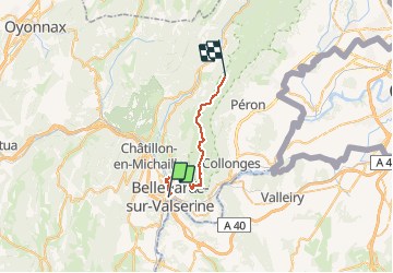
GTJ Bellegarde - refuge de

svp59
User

Length
27 km

Max alt
1610 m

Uphill gradient
1768 m
Km-Effort
47 km

Min alt
344 m

Downhill gradient
690 m
Boucle
No
Creation date :
2014-12-10 00:00:00.0
Updated on :
2014-12-10 00:00:00.0
10h09
Difficulty : Medium

FREE GPS app for hiking
 SityTrail
IGN / Geographical institutes
SityTrail Plus
The world is yours!
About
Trail Walking of 27 km to be discovered at Auvergne-Rhône-Alpes, Ain, Valserhône. This trail is proposed by svp59.
Description
GTJ Bellegarde - Refuge / chalet du SAc ou refuge de Poutouilles /
Positioning
Country:
France
Region :
Auvergne-Rhône-Alpes
Department/Province :
Ain
Municipality :
Valserhône
Location:
Bellegarde-sur-Valserine
Start:(Dec)
Start:(UTM)
718238 ; 5109945 (31T) N.
Comments