


Au pied du Bougnon

lenezdanslesetoiles
User
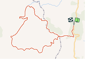

Length
14.7 km

Max alt
288 m

Uphill gradient
415 m
Km-Effort
20 km

Min alt
75 m

Downhill gradient
416 m
Boucle
Yes
Creation date :
2021-03-10 06:53:52.0
Updated on :
2021-03-10 09:29:06.062
2h34
Difficulty : Medium

FREE GPS app for hiking
 SityTrail
IGN / Geographical institutes
SityTrail Plus
The world is yours!
About
Trail Walking of 14.7 km to be discovered at Provence-Alpes-Côte d'Azur, Var, Roquebrune-sur-Argens. This trail is proposed by lenezdanslesetoiles.
Description
Un peu longue mais pas dure
Positioning
Country:
France
Region :
Provence-Alpes-Côte d'Azur
Department/Province :
Var
Municipality :
Roquebrune-sur-Argens
Location:
Unknown
Start:(Dec)
Start:(UTM)
311485 ; 4804849 (32T) N.
Comments