


Boucle Charly Chassagny

dan69390
User
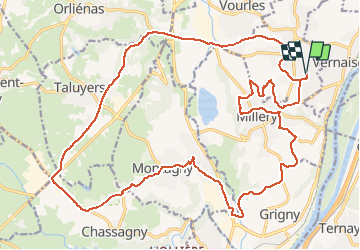

Length
28 km

Max alt
335 m

Uphill gradient
439 m
Km-Effort
34 km

Min alt
162 m

Downhill gradient
439 m
Boucle
Yes
Creation date :
2021-03-10 12:43:44.0
Updated on :
2021-03-10 14:37:01.629
1h52
Difficulty : Easy

FREE GPS app for hiking
 SityTrail
IGN / Geographical institutes
SityTrail Plus
The world is yours!
About
Trail Road bike of 28 km to be discovered at Auvergne-Rhône-Alpes, Métropole de Lyon, Charly. This trail is proposed by dan69390.
Positioning
Country:
France
Region :
Auvergne-Rhône-Alpes
Department/Province :
Métropole de Lyon
Municipality :
Charly
Location:
Unknown
Start:(Dec)
Start:(UTM)
640057 ; 5056056 (31T) N.
Comments