


mandagout

Bwattier
User
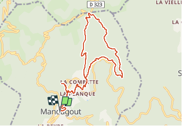

Length
11.5 km

Max alt
711 m

Uphill gradient
456 m
Km-Effort
17.6 km

Min alt
421 m

Downhill gradient
454 m
Boucle
Yes
Creation date :
2021-03-10 10:46:49.671
Updated on :
2021-03-10 15:21:54.973
3h44
Difficulty : Very easy

FREE GPS app for hiking
 SityTrail
IGN / Geographical institutes
SityTrail Plus
The world is yours!
About
Trail Walking of 11.5 km to be discovered at Occitania, Gard, Mandagout. This trail is proposed by Bwattier.
Positioning
Country:
France
Region :
Occitania
Department/Province :
Gard
Municipality :
Mandagout
Location:
Unknown
Start:(Dec)
Start:(UTM)
550198 ; 4874420 (31T) N.
Comments