


Sous Echallon Miribel

HB01
User
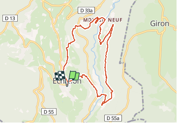

Length
9.9 km

Max alt
792 m

Uphill gradient
420 m
Km-Effort
15.5 km

Min alt
545 m

Downhill gradient
420 m
Boucle
Yes
Creation date :
2021-03-10 08:33:42.807
Updated on :
2021-03-10 15:53:51.579
2h56
Difficulty : Medium

FREE GPS app for hiking
 SityTrail
IGN / Geographical institutes
SityTrail Plus
The world is yours!
About
Trail Walking of 9.9 km to be discovered at Auvergne-Rhône-Alpes, Ain, Échallon. This trail is proposed by HB01.
Description
Départ du parking église-mairie d'Echallon.
Positioning
Country:
France
Region :
Auvergne-Rhône-Alpes
Department/Province :
Ain
Municipality :
Échallon
Location:
Unknown
Start:(Dec)
Start:(UTM)
711414 ; 5120965 (31T) N.
Comments