


SIGOYER Boucle Croix de la Biousse o l m s

RobinMicheline
User GUIDE
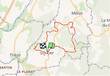

Length
16.3 km

Max alt
898 m

Uphill gradient
507 m
Km-Effort
23 km

Min alt
647 m

Downhill gradient
505 m
Boucle
Yes
Creation date :
2021-02-25 06:45:14.022
Updated on :
2021-03-10 17:10:55.546
4h25
Difficulty : Medium

FREE GPS app for hiking
 SityTrail
IGN / Geographical institutes
SityTrail Plus
The world is yours!
About
Trail Walking of 16.3 km to be discovered at Provence-Alpes-Côte d'Azur, Alpes-de-Haute-Provence, Sigoyer. This trail is proposed by RobinMicheline.
Description
Agréable, sympa , facile , bien indiquer, belle vue
Photos


Positioning
Country:
France
Region :
Provence-Alpes-Côte d'Azur
Department/Province :
Alpes-de-Haute-Provence
Municipality :
Sigoyer
Location:
Unknown
Start:(Dec)
Start:(UTM)
735880 ; 4911684 (31T) N.
Comments