


bueges2

Bwattier
User
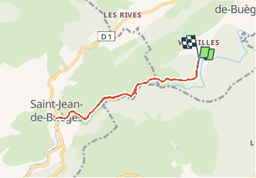

Length
7.5 km

Max alt
189 m

Uphill gradient
114 m
Km-Effort
9.1 km

Min alt
139 m

Downhill gradient
138 m
Boucle
No
Creation date :
2021-03-11 12:55:13.205
Updated on :
2021-03-11 14:55:29.052
1h59
Difficulty : Very easy

FREE GPS app for hiking
 SityTrail
IGN / Geographical institutes
SityTrail Plus
The world is yours!
About
Trail Walking of 7.5 km to be discovered at Occitania, Hérault, Saint-André-de-Buèges. This trail is proposed by Bwattier.
Positioning
Country:
France
Region :
Occitania
Department/Province :
Hérault
Municipality :
Saint-André-de-Buèges
Location:
Unknown
Start:(Dec)
Start:(UTM)
552417 ; 4853861 (31T) N.
Comments